Le Puy Bezin
Saint-Yrieix-le-Déjalat
Le Puy Bezin
Easy
3h
7,6km
+205m
-205m
Loop
Yellow markers
Embed this item to access it offline
The once bare and heather-covered puys have lost their sheep and shepherds. Pine trees now cover the mountains and contribute to a new economy: the wood sector.
2 points of interest
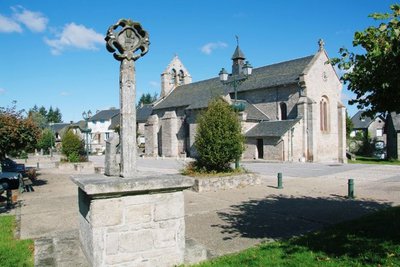
Eglise de Saint-Yrieix-le-Déjalat - D.Agnoux - CC VEM  Heritage site
Church of Saint-Yrieix-le-Déjalat
Dating from the 12th century, the church, whose patron saint is Saint Yrieix has a bell tower-gable, typically Limousin, with two bays. The portal includes an archivolt, a arch, five tori and five columns. In the square, a 17th-century cross recalls the location of the old cemetery. In the base, there is a very beautiful 12th-century granite capital. On the right is a winged demon with clawed feet, holding a stone to Jesus Christ, followed by an angel swinging an incense burner.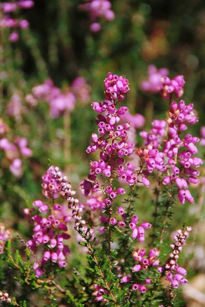
Bruyère cendrée - D.Agnoux - CC VEM  Flora
FloraHeather moors
Heather moors are dry moors made up of a low heather thicket (ash, ciliate, callune), with brooms, thorny gorse, juniper and blueberries. This type of heath developed with Neolithic clearings, followed by pastoralism. Until the beginning of the 20th century, 95% of the Monédières massif was covered with heather, ferns and junipers (compared to 20% today).
Description
- In the square, take the D16 towards Egletons and, before the cemetery, take the road on the right. Continue on the D135 on the right, leave the Plantade holiday centre on the right and continue.
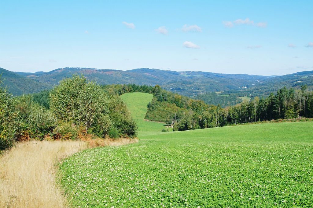
- Take the forest track on the right. It leads through stands of coniferous trees and passes on the northern side of the Puy Bezin (in the 19th century, a chapel dominated the moorland at the top of the Puy Bezin; today, the heather has disappeared and so has the chapel).
- At the crossroads, continue straight ahead. The track climbs up the Puy d'Aubart (view of the Monédières: from the dry heath of the Puy de Gussanges, on the right, to the coniferous plantations of the Puy Charrin, on the left, passing through deciduous forests and meadows, this panorama presents the multiple facets of the evolution of the landscape) and descends the northern slope in a few bends.
- At the junction, go down the track to the right.
- In the bend, set off on the path to the right. It goes down through the undergrowth, then alongside the valley of the Plantade which runs through wet meadows (called pastures). Cross the stream to arrive at the entrance to Laborde. Continue by the road that goes up in the hamlet and go past the houses.
- Follow the path on the right for 200 m, then go up by the path on the left into the beech woods. Continue along the small road, then take the D16 to the right to find the starting point again.
- Departure : Church, Saint-Yrieix-le-Déjalat
- Arrival : Church, Saint-Yrieix-le-Déjalat
- Towns crossed : Saint-Yrieix-le-Déjalat
Forecast
Altimetric profile
Information desks
Carrefour de l’Epinette, 19550 Lapleau
1 rue Joseph Vialaneix, 19300 Egletons
Access and parking
10 km northwest of Egletons on the D16.
Parking :
Church, Saint-Yrieix-le-Déjalat
More information
Report a problem or an error
If you have found an error on this page or if you have noticed any problems during your hike, please report them to us here: