The Gioux Path

Sornac Blue markers
The Gioux Path
Medium
4h30
16,3km
+341m
-341m
Loop
Embed this item to access it offline
A country walk starting from the village of Sornac, which takes you to the forest of Gioux via magnificent paths: fishing ponds, panoramic views of the Monts d'Auvergne, and granite village houses are the stars on this walk. On the way back, don't miss the short detour to the recently restored La Vialle fountain.
5 points of interest
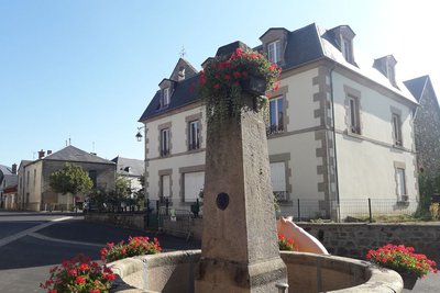
G.Salat - CC HCC  Heritage site
Sornac
The commune of Sornac, with 754 inhabitants at the last census, offers all the services of an attractive market town. Be sure to make a diversion to the magnificent church and its altarpiece on your way out or back.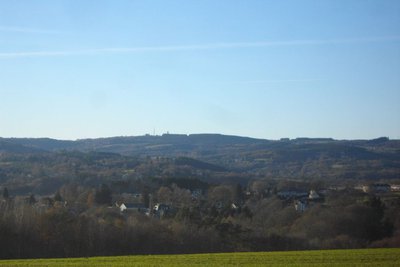
G.Salat - CC HCC  Panorama
Panoramic view of the water tower
This hike offers an unobstructed view at the water tower, which rises to 776 metres. Sometimes hidden behind cornfields, on your right is the volcanic massif of Sancy, the highest volcano in mainland France, at 1885 metres. On your left, recognisable by its civil and military antennas, Mont Audouze is a landmark on the Plateau de Millevaches.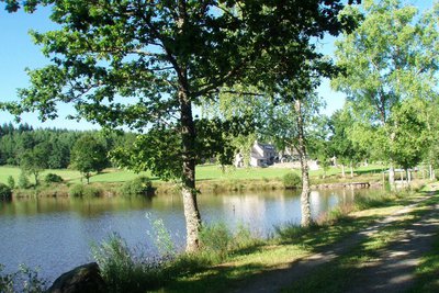
G.Salat - CC HCC PanoramaLes Anouilhards
The Millevaches plateau is not only the land of the "Thousand Sources": it is characterised by the presence of numerous ponds.
Some of the owners offer veritable tourist estates that are a fisherman's paradise: this is the case of the Anouillards site with its 9-hectare pond. This is also the case in the commune near the town surrounding the Chaux pond.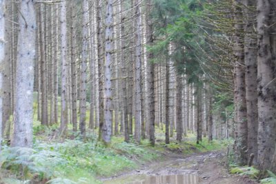
G.Salat - CC HCC Heritage siteThe Gioux reserve
The Voluntary Nature Reserve of Gioux, 66 hectares, was classified in 1994 by the will of its owner, M. Weill Hallé. Its interest lies in its isolated geographical location, the proximity of the pond, the Etang du Coudert, the variety of environments involved (although the walk only crosses the wooded part, there are also meadows and wetlands) and the diversity of protected species (otter, black woodpecker, little owl and Tengmalm's owl, common snipe, etc.)
Although the status of voluntary reserve has disappeared, this space still needs to be preserved: remain as discreet as possible, leave your pet at home, and no gathering (flowers, mushrooms), hunting or camping.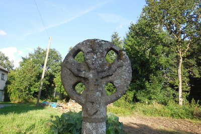
G.Salat - CC HCC Heritage siteThe fountain and the cross in La Vialle
The villages of Limousin were all heavily involved in agriculture. Walking through these hamlets always produces interesting discoveries during a hike: barns, large country houses, crosses and monuments, traditional local architecture, etc.
Don't miss the short return trip to the cool, refreshing fountain; and a little further, on the right the discoid cross of La Vialle
Description
Depart from Place de la Poste. Go back towards the church and take the lane on the left of the fountain, which joins the road to Ussel. Follow it to the left.
- In a bend before the last houses, follow the tarmac path on the left as it rises and becomes a trail.
- Join the road, which you follow on the left for 100 m, then follow the track which rises to the right. At the top, turn left, pass the water tower and go back down.
- Where the paths cross, turn right and then left. Take the road on the right and follow it. Go past the house; go right at the next crossroads. Before reaching a metal barrier, follow a trail in the undergrowth on the left. It goes down to Les Annouillards.
- After the first houses, turn right onto a path that leads through the woods and alongside the meadows. At a crossroads, fork left. Go right on at the next crossroads to join a road that you take to the left.
- Follow the road to the right for 500 m. Leave this road and turn left onto a path that enters the old Gioux reserve. At a crossroads, follow the path uphill to the left. On the flat, go straight ahead: the path passes between the meadows and joins a road.
- Follow it to the right. Ignore a road on the right and then turn left onto a path that leads to Lafage. In the village, go straight ahead a sunken path. Turn right at the tarmac road. At the end of the village, follow a grassy path to the left which joins the departmental road.
- Follow it to the left. Go through Les Chazeaux and Mont La Pinte At the crossroads, turn left for 50 metres, then take the track on the left. Follow it straight ahead as far as a Y-junction. Take the track on the right, which joins a road.
- Follow it to the right for 50 metres, then take the path to the left. At the crossroads, go straight on to find the path taken on the way out: leave the road after the first house to follow the path to the right. At the T-junction, turn right: go down to the road.
- Follow it to the right for 150 metres; turn left. When you reach the bend, take a short round trip to the fountain. At the next crossroads, follow the road to the left: it goes down into Sornac.
- Departure : Place de La Poste, Sornac
- Arrival : Place de La Poste, Sornac
- Towns crossed : Sornac and Saint-Rémy
Forecast
Altimetric profile
Information desks
Access and parking
From Ussel, take the D 982 towards La Courtine, then the D 21 towards Sornac
Parking :
Place de La Poste, Sornac
More information
Report a problem or an error
If you have found an error on this page or if you have noticed any problems during your hike, please report them to us here: