The Gorge Trail

Sérandon
The Gorge Trail
Medium
3h30
13km
+411m
-412m
Loop
Yellow markers
Embed this item to access it offline
Between the sky and the Dordogne, in the heart of a protected environment, the path overlooks the Dordogne gorges, the typical village of Vernéjoux, the sloping forests, the agricultural plateau and the village of Sérandon. Pleasant in all seasons, with perhaps a preference for the winter, where the absence of leaves makes it easier to see the river and the snowy panoramas of the Auvergne mountains.
11 points of interest
T.Colas - CC HCC  Heritage site
The village of Sérandon
Sérandon, with 349 inhabitants at the last census, derived its name from the root "serre" (highest point), to which the suffix "don" would add a defensive note.
On the way back from the hike, be sure to make a detour to the magnificent site of Gratte-Bruyère, which dominates the confluence of the Dordogne and Sumène rivers. This observatory is ideal for observing the booted eagle, the red kite, the short-toed snake eagle and the peregrine falcon.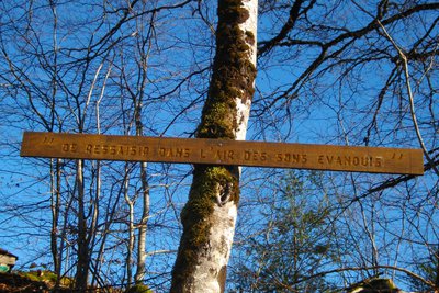
G.Salat - CC HCC Heritage siteStrange messages
The circuit is punctuated by wooden panels that deliver strange messages. This is an interpretive trail project developed around the five senses by students of the Neuvic high school.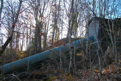
G.Salat - CC HCC Heritage siteThe penstock
The construction of a dam on the course of the Triouzoune has created a 410-hectare lake around the communes of Neuvic, Liginiac and Sérandon. The 5 km-long penstock in front of you starts at the dyke of the dam and carries the water to the Triouzoune power plant below. The small building at the start of the pipe is called a "balance chamber" and allows the flow of water to be regulated.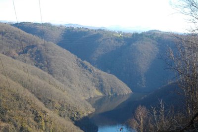
G.Salat - CC HCC  Panorama
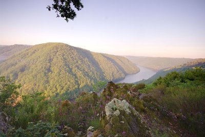
The Dordogne
Originating in the Massif du Sancy, the river Dordogne merges with the Garonne to form the Gironde estuary.
Between Corrèze and Cantal, the presence of gorges has favoured the construction of hydroelectric dams. At your feet is the Eagle Dam reservoir. 25 km long, it offers wilderness scenery with rocky cliffs, rocky scree and steep wooded slopes.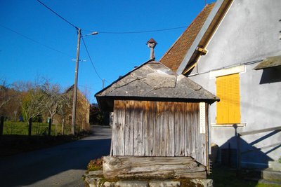
G.Salat - CC HCC Heritage siteThe village of Vernéjoux
The villages of Limousin were all heavily involved in agriculture. Walking through these hamlets always produces interesting discoveries during a hike: barns, mansions, crosses and monuments, traditional local architecture...
In the village of Vernéjoux, notice the farm buildings and the well.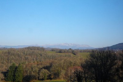
G.Salat - CC HCC PanoramaLe Massif du Sancy
This hike will offer you a remarkable view of the highest volcano in metropolitan France, the Puy de Sancy. At 1885 metres above sea level, this summit is the highest point of the Massif Central. The two streams, the Dore and the Dogne, originate there, and their confluence forms the Dordogne.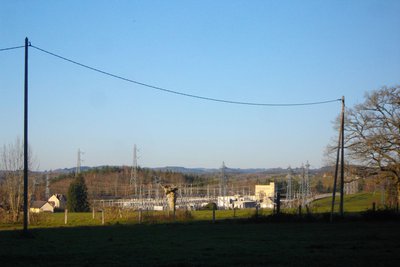
G.Salat - CC HCC Heritage siteThe Marèges power station
The La Mole electric substation is one of the largest in France. In particular, it supplies part of the Paris region and the SNCF network.
It is fed in part by the Marèges dam which is located below on the Dordogne river. This dam, the first to be put in water in 1935, is the subject of a short interpretation tour.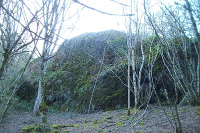
G.Salat - CC HCC PanoramaRocher du Grisot
The formation of the volcanic massif of Cantal has caused lava to rise over fragile areas in this northern part of the Dordogne. These upwellings are still visible today in the form of either small puys or shreds of flow. The Rocher du Grisot, which is, more generally, part of the Puy called Puy d'Enval or Puy de Vernejoux, is a witness hill or outlier cleared by the erosion of a flow whose origin remains unclear.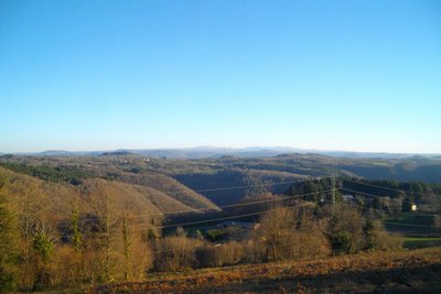
G.Salat - CC HCC PanoramaThe Cantal Mountains
As well as the Dordogne, there is a panoramic view over the Monts du Cantal. This massif is, in fact, the remnant of a stratovolcano born 13 million years ago, the largest in Europe, eroded by collapse and glacial erosion.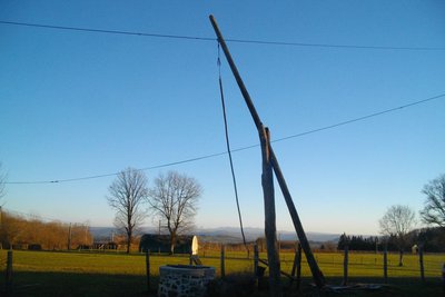
G.Salat - CC HCC Heritage siteThe village of Monange
At the end of the walk, in the village of Monange, you will find not only an old, traditional oven but a pendulum well. Its operates on the lever principle: It is supported in its centre on a pivot and carries a container at one end and a counterweight at the other. Simply vary the weight of one of the arms to give it a rocking movement.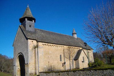
G.Salat - CC HCC Heritage siteThe church at Sérandon
Both the high point and the end of the route, the church of Sérandon is one of the prettiest in the region. Its porch, listed as a Historic Monument, is framed by a string of sculptures of symbolic figures and animals. Four scenes with carved characters move forward.
Description
Park in the town hall car park. Take Rue du Moulin Barriè. Continue straight ahead
- At the crossroads before the mill village, follow the road to the left. Go right at the next crossroads. Head towards the city of Vermillard.
- After the first house, take the path on the left; go along below the water tower. The path goes down in twists and turns into a path that you need to follow on the left for 200 m. Take a trail on the right that winds down to a small road.
- Go up to the left (right for the more difficult variant) to the crossroads.
- Go up alongside the stream, cross the road and then take the trail opposite. It winds its way up through the woods and joins a track that you followed on the right for some time.
- Follow the track on the right that goes down to the gorge and then up again. At the crossroads, follow the tarmac track on the right to reach Vernéjoux.
- In the village, take the second road on the right that leads to Enval. After a farm on the right, take the track on the left. In a bend, ignore a path on the right. Proceed: the track goes around the Puy d'Enval and joins a road.
- Turn left onto it; continue straight ahead ignoring several roads on your right and left. Go through Monange, passing an old oven and a well.
- After the last house, leave the main road and turn left towards the houses numbered 16 to 25. This little road becomes a path. Proceed. Go straight on at the crossroads after the meadow to join a road that you take on the right. Turn right at the next crossroads to reach the start, passing in front of the church.
- Departure : Village of Serandon
- Arrival : Village of Serandon
- Towns crossed : Sérandon and Liginiac
Forecast
Altimetric profile
Recommandations
Be sure to wear sturdy shoes: take care on the descent.
This tour includes a more difficult variant which is the subject of a descriptive sheet.
This tour includes a more difficult variant which is the subject of a descriptive sheet.
Information desks
Access and parking
From Neuvic or Liginiac, follow the D20 then head towards Sérandon
Parking :
Village of Serandon
More information
Report a problem or an error
If you have found an error on this page or if you have noticed any problems during your hike, please report them to us here: