
The water path
A circuit where the old buildings and remarkable natural heritage blend together to delight lovers of old stones and unspoilt nature. The Plateau de Millevaches never ceases to surprise us and transport us to strange and unknown worlds that engrave these wonderful moments on our memory.
4 points of interest
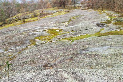
Les rochers de Clamouzat - Le Lac de Vassivière  Geological interest
The rocks of Clamouzat
This protected site, covering 116 hectares, is also of great botanical and geological interest, making it quite remarkable. The large 200 m long rocky slab like a "whale's back", allows you to make sense of a superb landscape of moors and peat bogs and more in the distance, and the many volcanic cones of the Plateau de Millevaches.

 Site
SiteThe Chammet Dam
This walk offers a very deep lake of 87 ha, nestled in a basin of the Chandouille in a setting carpeted in heather in the heart of the Plateau de Millevaches. A place much appreciated by fishermen for the diversity of its fish. This peat bog is a peaty alveolus occupied by wet moors and dry heaths. The wet moors are home to areas of unstable peat bogs where Drosera grows. The presence of juniper bushes makes this site remarkable because it is very rare in Limousin.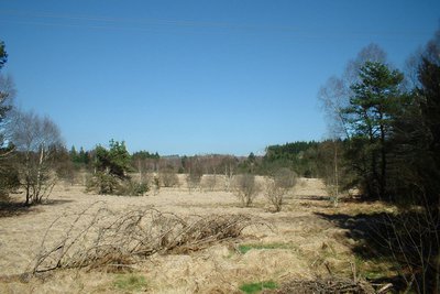
Tourbière de la Ribiere - Le Lac de Vassivière  Flora
FloraHeath
This landscape feature, ever-present on the Plateau de Millevaches, offers unique habitats where the richness of the fauna and flora make this little corner of France an authentic, preserved and exotic place.
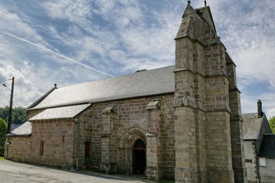
L'église de Faux-la-Montagne - B.Biache  Heritage site
The church of Faux-la-Montagne
This church, dedicated to Saint-Etienne, the first Christian martyr, was built in the 13th century and was listed as a historic monument in 1963. Its restoration in 2010 revealed its pink granite masonry, eight centuries after its construction.
Description
- From the car park 200 m below the intersection between the D992 and the road leading to Jalagnat, take the latter to the right. After the housing development, go down the path to the right.
- Cross the Pont de la Gane, follow the upward path and turn left onto the path beneath the trees. Pass between two meadows, and you arrive at an intersection.
- Leave the track on the right and take the trail to the right 20 m further down. Pass between two low walls and arrive at a crossroads.
- Turn left (here you can go and see a ""miniature"" mill, taking the track on the right). Go through the woods and peat bogs, blueberries in season. Find the road, and follow it on the right for 50 m.
- Take the path on the left (if you continue straight ahead, you can go to Les Rochers de Clamouzat). Walk alongside the ruins of a shepherd's hut, and you arrive in front of three remarkable beech trees. Cross the road and continue straight along the same path. The village of Arzaillers is on the right. Variant: to shorten the circuit (9 km): take the road on the left for 200 m and follow the GR 440.
- Cross the road, take the path in front of you and continue to the right on the GR leading to the EDF Holiday Centre (you can go to see the Chammet dam by going through the Centre and following the GR on the right).
- Before the Centre, go up a path on the left. To reach a viewpoint overlooking the bog of the Ribière de l'Age, cross the D85. Continue straight ahead, arrive on the D16 and turn right until you reach Loudoueineix.
- In this small typical Limousin village, on the left, go up the small road that turns into a path. At the crossing continue straight ahead, passing in front of the Croix de la Gane. Ignore one path on the right, take the next one on the right, then immediately go left.
- Go through a forest (you can see a moor on the right), and you arrive on a track. Turn right then left, go through the hamlet of Bessat and follow the small road to the right.
- Take the D85 for 200 m to the right (you can see the Bessat-Bellevue bog on the right).
- Take a path on the left. Leave a path that starts on the left. Pass between two low walls. You come out on the D3.
- Turn right to return to Faux-la-Montagne.
- Departure : Car park, Faux-la-Montagne
- Arrival : Car park, Faux-la-Montagne
- Towns crossed : Faux-la-Montagne
Forecast
Altimetric profile
Recommandations
Information desks

Place Quinault, 23500 Felletin
Rue de Vassivière, 23460 Royère-de-Vassivière
Transport
Access and parking
28.5 km from Felletin, take the D992.
Parking :
Accessibility
- Emergency number :
- 112
More information
Report a problem or an error
If you have found an error on this page or if you have noticed any problems during your hike, please report them to us here: