Le Puy Raynaud moor
Over an area of about 2700 ha, discover the commune of Clairavaux (Clara vallis "the clear valley"). The site offers a diversity of environments characteristic of the Creuse valley and is full of remarkable historic local buildings. Throughout your journey, several viewpoints allow you to admire the landscapes that make up the Upper Creuse Valley.
Attachment
- Downloadpdf
Livret de découverte de la lande du Puy Raynaud
Credit: PNRML
4 points of interest
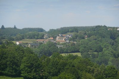
Bourg de Clairavaux - PNR de Millevaches en Limousin  History
The village of Clairavaux
Originally, and according to oral legends, the ancient village of Clairavaux was located near the Bois des Trembles, in Branges and was called "Pyravaux" (porous valley). From the heights, the village has a view over the valley, useful in times of war to prevent the arrival of invaders. The village is arranged like most of the villages in the Limousin Mountain. It has a grouped form with about twenty houses. The dwellings cluster tightly around the church, surrounded by parks and gardens, without being directly overlooked. Near the village, there are meadows for livestock, bordered by hedges.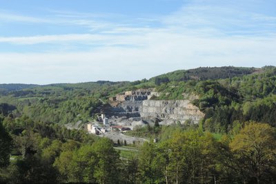
La Carrière - PNR de Millevaches en Limousin  Geological interest
The Quarry
On the left bank of the Creuse, located on the hillside, Clairavaux's quarry has been extracting gneiss for nearly a century. The gneiss is processed on-site and then delivered to local construction and work companies. The production of gneiss aggregates from this quarry reaches 100,000 tonnes per year. The Clairavaux quarry was able to develop thanks, in part, to the immediate proximity of the railway. After the closure of the Felletin-Ussel section in 1979, Clairavaux station was subsequently destroyed. Despite the closure of the line, the convergence towards the bottom of the valley is still present today.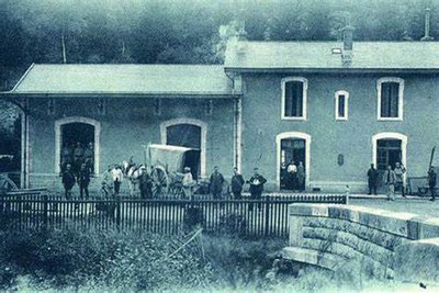
La gare de Clairavaux - DR HistoryThe railway line
The old railway track has now been lifted. This line, owned by the Paris-Orléans railway company, connected Busseau-sur-Creuse to Ussel for nearly 80 km. The Clairavaux station was the tenth stop, between Croze in the north and Mas d'Artiges in the south. The Felletin-Ussel section opened on June 1st. On the day of the inauguration, August 4, 1905, there were great celebrations around the inaugural convoy. The railway was of great importance for military disarmament transport and troops going on manoeuvres at La Courtine camp.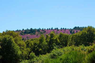
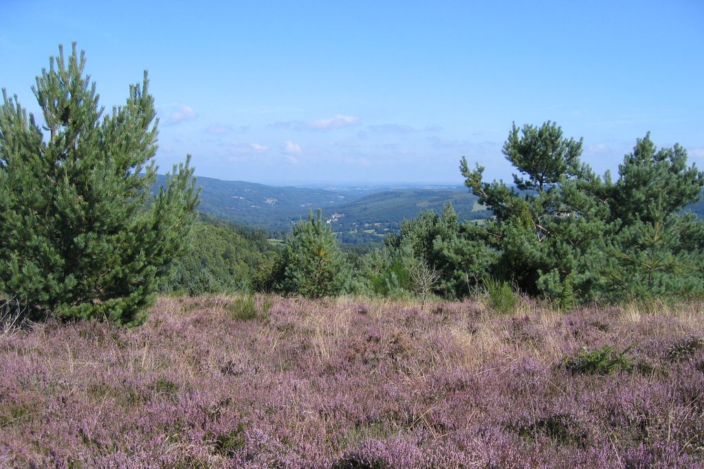
PNR de Millevaches en Limousin  Flora
FloraThe moorland
Landscapes once common in Limousin, the moors have experienced a considerable decline since the 1950s in connection with the decline in agriculture. Today, the moorland of Puy-Raynaud is a unique heritage site. From the summit, you will see the valley of the Creuse. This dry moorland culminates at an altitude of nearly 850 m. It is mainly composed of Calluna (Calluna vulgaris) often called common heather, which blooms at the end of August. The presence of the eagle fern, brooms and woodland pine plantations testify to the gradual degradation of this ancient moorland by the abandonment of grazing.
Description
Depart from the church square. Go back up into the village and turn right into an alley. Go right at the next crossing to reach a grassy path that goes down to a pond.
- Take the road on the right to reach the crossroads. Cross over the D982 and turn left onto a tarmac path that goes along at the foot of the quarry. It turns into a grassy path; it is a former railway line. Follow it for 2 km.
- Take the road on the right which goes through Laveix and Raynaud.
- 600 m after Raynaud, turn left onto the forest track. It rises above the meadows. Leave it for a path that climbs up into the undergrowth and leads to a moor. Carry on, following the level pathway. Cross a fence, and you find, on the edge of the military property, a path which you follow to the right.
- At the crossroads, turn right to go down to the protected spring head. At the catchment level, follow the path alongside the stream to the road. Turn left onto it to reach Abat.
- In the village, take a tarmac path on the right. It joins a road on the right that you take to reach Teix. At the crossroads (outdoor laundry on the left), take the path that goes down and joins a road that you take on the left for 200 m. Take a path on the right that descends to the D982.
- Cross it, go around the old gatekeeper's house and follow the track (the old railway) for 500 m. Leave it to take a path on the right that crosses the River Creuse and leads up to an old mill.
- Cross the road and take a steep path almost opposite. Go up by this small stream and then turn right onto a path that joins the road. Turn left onto it to reach Clairavaux.
- Departure : Church square, Clairavaux
- Arrival : Church square, Clairavaux
- Towns crossed : Clairavaux
Forecast
Altimetric profile
Recommandations
The moorland of Puy Raynaud, once grazed by sheep, is a sensitive environment that must be preserved.
Information desks

Place Quinault, 23500 Felletin
Access and parking
15 km from Felletin, leave the D982 to go up to the village of Clairavaux.
Parking :
More information
Report a problem or an error
If you have found an error on this page or if you have noticed any problems during your hike, please report them to us here: