The roof of the Limousin

Meymac
The roof of the Limousin
Difficult
4h30
21,2km
+532m
-532m
Loop
Yellow markers
Embed this item to access it offline
Rise up onto the Limousin Mountain following the local Beech Road and observe through huge window-like openings cut through the forest, the distant horizons that open onto the Monts d'Auvergne, with, in the foreground, the high Corréziens plateaus and the countless valleys where the rivers snake through. Descend to explore the wetlands at the bottom, where peat bogs have been forming for thousands of years. Turn your head to the right, to the left, here nothing is the same; here everything is magnificent; here you can breathe.
4 points of interest

Vue du Mont Bessou - CC HCC  Panorama
Tour of Mont Bessou
Climb the few steps of the Mont Bessou Panoramic Tower, which elevates you to the highest point of the Limousin and Limousin Mountain, at an altitude of 1,000 m. Discover the Millevaches plateau in front of you... Do not look for the shepherdess or her flock, which were transformed, according to the legend, by the devil into 100 stones (see the site of the Hundred Stones). Don't linger either, as a good etymologist, looking for the 1,000 pools or 1,000 streams that meander through the caves and hollows, feeding the pastures (wet meadows) and peat bogs, before swelling the waters of the Dordogne and Loire rivers. Finally, don't think that the Limousin highlands look like a chain of puys, the cones of extinct volcanoes, like those in the Auvergne which you can see in the distance. They are much more like a dull succession of heavy hills and hollows separated by barely marked valleys... the landscape of Millevaches is magnificent.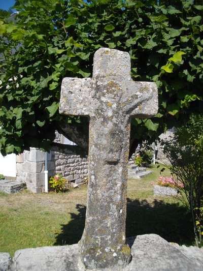
Lavaur - Croix - CC HCC  Heritage site
Village of Lavaur
Perhaps you will have the opportunity to discover, in the valleys, the remains of a partially obliterated landscape... former agricultural terraces laid out by human beings to trap good soil... or even ingenious irrigation levades, large gullies dug in the meadows and supplied with water by a basin above (a pond perhaps with fish)... or finally, sunken lanes bordered with old beech trees and low dry-stone walls. It is hard to imagine today how these landscapes could have looked; this little exercise may help you: As you leave the village of Lavaur, turn around, look at the hamlet as a whole and, squinting, ignore all the trees that surround it...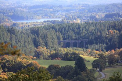
Viaduc des Farges - CC HCC  Site
SiteDouglas des Farges
You will find the Douglaseraie des Farges, and this is another worthwhile detour... The viaduct, built in 1882, is the largest in Limousin. It is a reminder that the forest and softwoods arrived with the railway. The people left, and the forest settled down in their place where it became something quite remarkable. The Douglaseraie des Farges is distinguished by its age and the quality of its population of trees, which reach 50 m high and 3 m in circumference, each representing about 15 m3 of wood. Nature seems to have partially finished its work; it is now humankind's turn to surpass itself.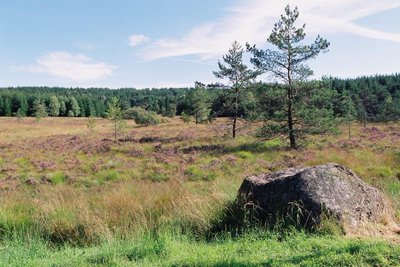
Mairie de Meymac  Peat bog
Peat bog
For the peat bogs, imagining what these landscapes were like seems easier... apart from the development of some of them into lakes or ponds, the majority seem to have been abandoned. Was their exploitation less profitable ? Did the beliefs and legends inspired by these hostile environments hinder their development ? Is it simply their great agethat commands respect? This remarkable natural environment, now classified as one of Europe's ecological treasures, began its transformation about 8,000 years ago. It hosts an extremely rare procession of flora and fauna (viviparous lizard, drosera, etc.). The famous Tourbière du Longeyroux, a peat bog classified as a Natura 2000 Site, now enjoys a high level of European protection.
Description
From the Mont-Bessou tower car park, go straight down the road to the village of Lavaur.
- In Lavaur, turn right onto the D979 E3 (Variant: continue straight ahead). Then turn left towards the village of Lespinat.
- In Lespinat at the D109, turn right and then immediately left. The road becomes a path. Join a forest track that you take on the right. Continue straight on for 1 km and then take the small road on the right. Go through Le Goumoueix and return to the D109 (off the trail on the left: The return journey to the Douglaseraie des Farges takes about 5 minutes).
- Take the road on the right and then, after the railway bridge, take the second path on the left. This rises; turn left at the next crossroad and reach the Beech Road.
- Take the road on the left for a long time, leaving pathes on your left and right. Leave on your left the road to Le Cloup, carry on the Beech Roads for another 1,5 km.
- At the track, take it on your left. Leave the path on the right and when you come to the D979.
- Cross it to follow a track. Leave the track on the right and continue straight ahead until you reach a T-junction. Take the track on the right. Ignore another track on the right. At the T-junction, turn right. Continue for 1 km and turn left to join the D979.
- Cross it and continue straight along this small road. At the next crossroads, turn left and then take the path on the right at the car park. At the next path crossing, turn right to go up to the panoramic tower.
- Departure : Tower of Mount Bessou, Meymac
- Arrival : Tower of Mount Bessou, Meymac
- Towns crossed : Meymac and Ambrugeat
Forecast
Altimetric profile
Recommandations
Departure from Sechemailles: from the holiday village, head towards the lake and turn right. Follow the lake to the Ambrugeat car park, crossing the beach, the fitness trail and the two culverts in succession. Opposite the chateautake the minor road towards Le Goumoueix.
If it offers pretty views, the road of the haggeries constitute a long paved portion
If it offers pretty views, the road of the haggeries constitute a long paved portion
Information desks
Access and parking
6.5 km from Meymac, take the D36.
Parking :
Tower of Mount Bessou, Meymac
More information
Report a problem or an error
If you have found an error on this page or if you have noticed any problems during your hike, please report them to us here: