From the site of Les Cars to Longeyroux
Saint-Merd-les-Oussines Blue markers
From the site of Les Cars to Longeyroux
Difficult
4h30
16,4km
+395m
-395m
Loop
Embed this item to access it offline
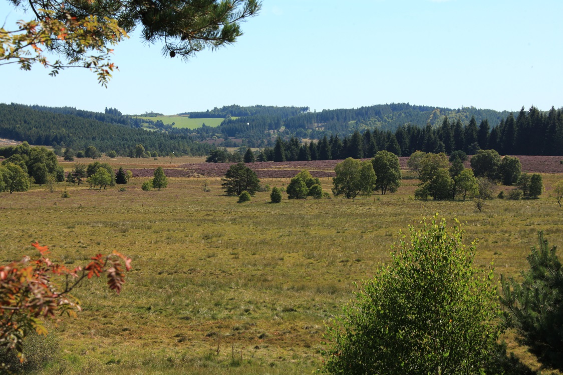
One of the iconic trails of the Plateau de Millevaches which allows you to discover the variety of its landscapes: softwood and hardwood forests, peat bogs and wetlands, meadows and villages of granite. Explore them in all the four seasons, as the atmosphere changes throughout the year. A favourite is the month of August when the heather is in flower.
4 points of interest
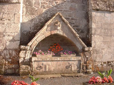
Enfeu - St-Merd les Oussines - g.salat  Architecture
The village of Saint-Merd les Oussines
What a curious name is that of St-Merd, which is, in fact, a contraction of St-Médard; a miraculous fountain is dedicated to him at on the outskirts of the village as you go towards the cemetery. Outside the church, notice a tomb (funerary niche), possibly the burial place of a lord of Les Oussines, an old medieval estate located in the town. Inside, a carved tomb topped with a figure may house the burial of a dignitary of the Order of St. John of Jerusalem.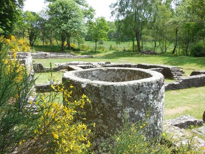
Site gallo-romain des Cars - g.salat  Archaeology
Gallo-Roman remains at Les Cars
The Gallo-Roman remains of Les Cars are composed of two funerary buildings and a huge dwelling located 200 m. below. The presence, in the heart of an agricultural estate, of an impressive villa owned by a landowner linked to two private mausoleums, dating from the 2nd and 3rd centuries AD, is a hypothesis that remains to be confirmed. This site, famous for its monolithic granite tank, is open all year round.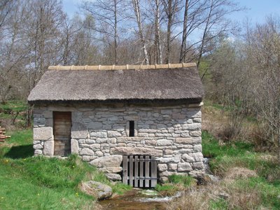
Moulin des Maisons - g.salat  Small patrimony
Moulin des Maisons
There is no small river in Haute-Corrèze that was not used by one or more mills; every farm, every village had its own. Of modest size, they were most often used to grind grain for livestock feed. Proof of the population's attachment to its local heritage, the Moulin des Maisons has been carefully restored.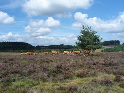
Vaches limousines sur la tourbière du Longeyroux - G.Salat - CC HCC  Peat bog
Longeyroux peat bog
The Longeyroux peat bog (255 hectares) occupies the bottom of a basin that collects rainwater from the surrounding puys; This is how the Vézère river was born. A cold and humid climate and an acid granitic soil have favoured the development of distinctive fauna and flora. A short, 30-minute interpretation trail provides a better understanding of this environment. To preserve this ecosystem, the site's enhancement policy encourages grazing by Limousin sheep and cows.
Description
Depart from the war memorial; head in the direction of Les Cars.
- At the crossroads after the bridge over the Vézère, a path rises 30 metres in front between the houses. At the height of the small barn, take the path on the right between two low walls. It extends into a track through the undergrowth that climbs and then descends to the left towards the road.
- Follow this road on the right; then turn left at the next crossroads to Les Rioux. In the village, the path on the right that passes above a thatched property leads to the Les Cars site (40 mn round trip).
- Continue on the road to Les Maisons. Go down into the village; a track passes in front of the restored mill. At the crossroads, turn left onto a track that climbs into the woods. Follow it for 600 metres and then take a path on the left that crosses a heather moor. At the end of the plot, continue straight ahead, the path runs alongside a meadow. At the bottom of the valley, this path becomes a stream: go up onto the bank; two small bridges allow you to cross it. A wide track leads you to the village of Celle.
- Go through it. 200 m after you leave the village, a short path on the left joins a road. Follow it on the left to reach the reception area for the Longeyroux peat bog (off the circuit: it is possible to go down the interpretation trail - 30-minute circuit).
- Continue on this road for 500 m; in a bend, take the track which goes straight ahead.
- Where the tracks cross, continue straight on the path that rises and then enters the forest. Go along the fence to go through the wetland. The path continues in the woods. When you get up to a meadow, fork left to join the Borde.
- Continue by the small road. Turn left at the next crossroads to reach St-Merd.
- Departure : War Memorial, Saint-Merd les Oussines
- Arrival : War Memorial, Saint-Merd les Oussines
- Towns crossed : Saint-Merd-les-Oussines, Pérols-sur-Vézère, and Meymac
Forecast
Altimetric profile
Recommandations
Allow two more hours to visit the sites of Les Cars and Le Longeyroux (these two sites are open freely all year round)
Attention: provide suitable shoes in case of heavy rain and, on the way back, do not hesitate to climb on the right side of the path to bypass the puddles
Attention: provide suitable shoes in case of heavy rain and, on the way back, do not hesitate to climb on the right side of the path to bypass the puddles
Is in the midst of the park
The national park is an unrestricted natural area but subjected to regulations which must be known by all visitors.
Information desks

Access and parking
12 km from the tourist information office in Bugeat. From Bugeat, follow the D979 towards Meymac. As you leave of the village, turn left onto the D979E1 then the D164 towards St-Merd.
Parking :
War Memorial, Saint-Merd les Oussines
More information
Report a problem or an error
If you have found an error on this page or if you have noticed any problems during your hike, please report them to us here: