The Roman bridge
Merlines
The Roman bridge
Difficult
5h
23,5km
+529m
-529m
Loop
Yellow markers
Embed this item to access it offline
From the starting point, you can see the magnificent Chavanon motorway viaduct. Much more modest, the so-called "Roman" bridge allows you to cross the Barricade stream. Although the exact date of its construction is not known, a crossing structure already existed in 1818. Its recent restoration (2019) has enhanced this bridge. Shortly afterwards, a short return trip reveals the remains of a mill. On the second part of the loop, you will take a long walk along the old railway line which connected Bort les Orgues to Merlines while skirting the gorges of Chavanon.
6 points of interest
G.Salat - CC HCC  Site
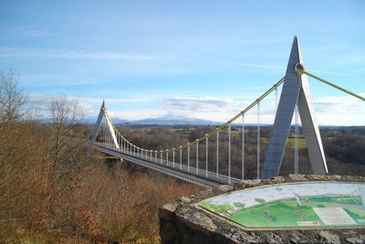
SiteThe A89
Between Auvergne and Limousin, the suspension bridge over the Chavanon crosses this eponymous river and offers a magnificent view over the Massif du Sancy.Nicknamed the "presidents' motorway", it crosses the political strongholds of Valery Giscard d'Estaing, Jacques Chirac and François Hollande, the A 89 links Bordeaux to Lyon by crossing the Massif Central. It is 550 km long and was put into service along its entire route in 2018.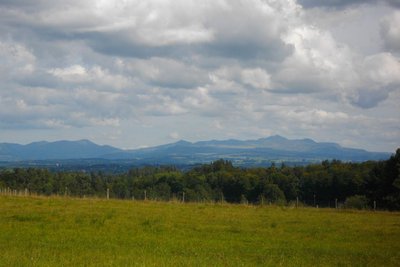
G.Salat - CC HCC  Panorama
Le Sancy
This hike will offer you several viewpoints overlooking the highest volcano in mainland France, the Puy de Sancy. At 1,885 metres above sea level, this summit is the highest point of the Massif Central. The two streams, the Dore and the Dogne, originate there, and their confluence forms the Dordogne.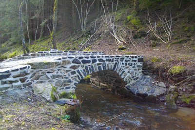
G.Salat - CC HCC  Heritage site
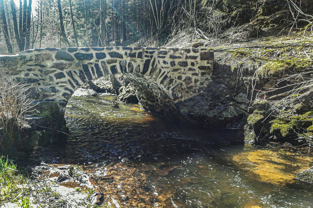
The Roman bridge
Thanks to help from the Departmental Council, a subscription, and help from the Bern mission as part of the heritage lottery fund, via the Heritage Foundation, the Roman bridge at La Veyssade, in Merlines, was saved in 2018.Even though it is said to be "Roman", the exact date is not known; The only certainty is that a structure appears at this location on a cadastre (land registry document) of 1818. It crosses the Barricade stream.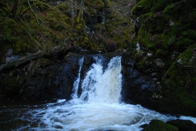
G.Salat - CC HCC  River
RiverThe Barricade stream
The Barricade, 12 km long, has its source on the Plateau de Millevaches among the peat bogs. Once past the Roman bridge, it abruptly drops away to join the Chavanon. Crossing this rocky barrier gives birth to a small waterfall. You can see the remains of the mill at Faux, a village located on the plateau, where the power of water was used to turn the millstones...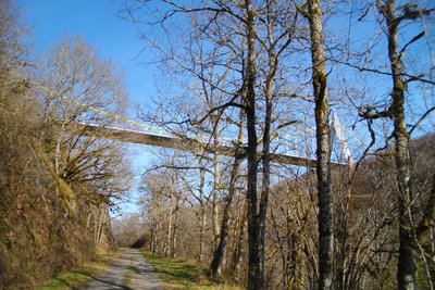
G.Salat - CC HCC Heritage siteThe old railway line
One may be surprised to see such a beautiful flat path, but soon the size of the walls reminds one of the remains of a railway. We are on the old Paris-Béziers line, which crossed the Massif Central. The filling of the Bort les Orgues dam led to the closure of the line in 1950. This track also allows gives you an original view over the Chavanon viaduct.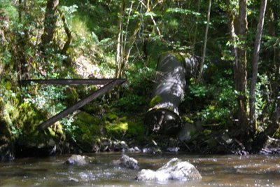
G.Salat - CC HCC Heritage siteThe Lagarde dam
The Lagarde dam was in operation from 1909 to 1920, supplying electricity to the railway station at Merlines. A real railway junction between the Paris-Béziers and Bordeaux-Lyon routes, it was the second most important station in Corrèze for freight. An iron pipe, the remains of which can still be seen, led from the dike to a small power station.
Description
Retrace your steps. Leave the Lagarde road on the right and turn left.
- Follow this road for 1.5 km, ignoring several paths on your left.
- When you see Les Bourrandes, take a path to the left. Turn left at the next crossroads; The path gradually becomes a trail (follow the markings carefully) and then forks to the right: it is not very clear to see in the woodland undergrowth. It joins a path, which you take to the right. Turn right onto the road.
- At the crossroads, turn left towards "Aire du Chavanon" for 200 m, then take the path on the right. Turn left at the Y-junction: continue on the main path; turn right at the crossroads when you reach the meadow; ignore a path on your right a little further on.
- Take the road to the left; go over the railway bridge. Continue. Turn left at the next crossroads and cross the railway line again.
- After the bridge, follow the track to the right. Turn left at the next crossroads. At the pond, take the track on the right. This becomes a path. Go straight down to the Roman bridge.
- Go up for 100 m and take a trail (difficult to spot) on the right that crosses a small stream. Continue through the woodland undergrowth. Turn left at the next crossroads. At the end, turn right and go back to the Barricade stream. Go up to a point where the tracks cross.
- Turn right: stay on this gravelled track leaving several paths on your right. Take the road on the right for 200 m. then follow the tarmac track on the left towards Lespinat. Go through the village; 400 m further on, take the path on the right. Follow the trails to the left and then the path to the right, and the route you took at the start.
- Follow the track to the right (straight ahead to return to the start), pass under the motorway bridge. Follow the track to the right after the bridge. Turn left at the Y-junction. Continue straight on the main road.
- At the end of the road, turn left onto a path; continue straight ahead: At the edge of the gorge, this path becomes a trail: go straight down. At the bottom, go straight on until you reach a wide track that you take on the left.
- Follow this old railway line for 3 km, passing under the motorway viaduct (off the circuit: 200 metres after the viaduct, following the sign "barrage de Lagarde, you can go down to the edge of the Chavanon).
- At the bridge, leave the track and follow the path on the left that goes up to Lagarde. In the village, follow the road to the right and then to the left. 100 m after the village, follow the road to the left to find the starting point again.
- Departure : Belvedere of Chavanon, Merlines
- Arrival : Belvedere of Chavanon, Merlines
- Towns crossed : Merlines and Aix
Forecast
Altimetric profile
Recommandations
Coming from Ussel, follow the RD 1089 towards Clermont-Ferrand; In Merlines, turn to the right and be careful; the circuit does not start from the village of Merlines but from the belvedere of Chavanon. A shortcut (15 km - three and a half hours) is the subject of a specific description sheet. Head towards "belvédère du Chavanon".
Information desks
Access and parking
Coming from Ussel, follow the RD 1089 towards Clermont-Ferrand; in Merlines, turn right and head towards "belvédère du Chavanon".
Parking :
Belvedere of Chavanon, Merlines
More information
Report a problem or an error
If you have found an error on this page or if you have noticed any problems during your hike, please report them to us here: