Along the granite trail
Chaveroche
Along the granite trail
Medium
3h
11km
+310m
-310m
Loop
Yellow markers
Embed this item to access it offline
From the traditional architecture and, in particular, the church at Chaveroche to the rocks in the Diège river bed, this walk is marked by the imprint of granite. However, with geological infidelity to this rock, there is a panoramic view of the Auvergne volcanoes towards the highest point of the hike.
3 points of interest
J.Primpier - PNRML  Heritage site
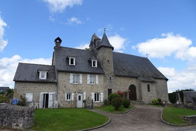
The village of Chaveroche
The church-presbytery of St. Clair dates from the 14th century and was remodelled in the 17th century. The cross in the cemetery also dates from the 14th century. The traditional architecture of the Correze is represented in the various houses that make up the village of Chaveroche.
J.Primpier - PNRML  Geological interest
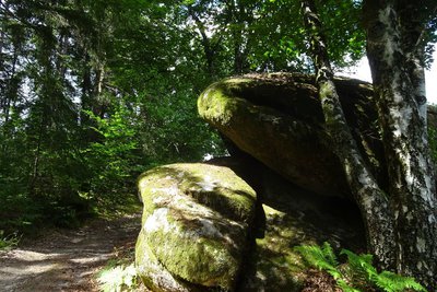
The use of stone
The migrant masons of the Limousin built their houses applying at home what they had learned on the large building sites in the big cities: facades in dressed stone, masonry works carried out with stone rubble and earth and lime mortar. Martin Nadaud, born in Creuse, is an iconic figure among these migrant masons. Granite rock is present throughout the walk in scattered blocks in the forest, low walls, bridges or other constructions.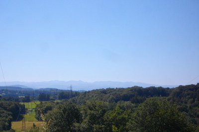
V.Mendras - CC HCC  Panorama
Le Sancy
This hike will offer you a remarkable view of the highest volcano in metropolitan France, the Puy de Sancy. At 1885 metres above sea level, this summit is the highest point of the Massif Central. The two streams, the Dore and the Dogne, originate there, and their confluence forms the Dordogne.
Description
From the Chaveroche church car park, follow the D 67 to the right towards Saint-Angel. Just after the cemetery, turn right into the multi-purpose hall car park. Go through it.
- Take the small road to the right to arrive at Chaverochette. Continue through the woodland undergrowth around a left-hand bend, then a right-hand bend to reach a crossroads (return route opposite).
- Turn to the right along the path. At the T-junction, go up the small shady road on the left. At the end of the tarmac, go past the entrance to a house and continue for 40 m. At the fork in the road, go down the trail on the right andinto the undergrowth. Cross the stream (granite bridge), go back up and 30 m after the Rocher de la Poule (large granite block on the right), under the high voltage line, take a path on the right which leads to a road (view over the Sancy massif).
- Turn right towards the hamlet of Le Chassaing. Fork left just after the barn and go up a path.
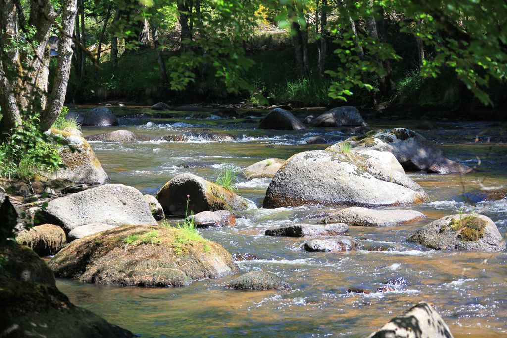
- At a fork in the road, go straight as far as La Diège following the sign "au fil du granite" (ignore the path signposted "Pierres qui roulent" on the right). Follow the river (natural site of Petit-Confolent) to the D 49, which you take on the left for 800 m.
- Turn left towards the hamlet of Neuf-Jours and climb through the deciduous undergrowth to a fork in the road. Turn right (small Chaveroche sign). Follow a vast clearing to the bend (panoramic view of the Puy de Sancy to the Cézallier mountains). Go straight up below the high voltage line in a coniferous forest (ignore the prohibition cross on a tree on the right), then, on the level, turn sharply left onto a track lined with old Douglas fir trees.
- At the end of the road, turn right onto the tarmac track. After 300m, at the small building, turn left. Go down the valley (view of the Cantal mountains) to the hamlet of Le Queyriaux, which you leave on the left.
- Take the small road to the right. At the fork, continue to the left, past a stream and then up (past a large granite block on the left bank with marks of the old stonemasons' work). At the fork, take the forest track to the left. At the junction, go straight on to join the crossroads at point 2. Then follow the route in the opposite direction to Chaveroche
- Departure : Church Square, Chaveroche
- Arrival : Church Square, Chaveroche
- Towns crossed : Chaveroche, Saint-Pardoux-le-Vieux, and Saint-Germain-Lavolps
Forecast
Altimetric profile
Recommandations
The banks of the Diège can sometimes be flooded during rainy periods.
Information desks
Access and parking
7.6 km from Ussel, follow the D 157.
Parking :
Church Square, Chaveroche
More information
Report a problem or an error
If you have found an error on this page or if you have noticed any problems during your hike, please report them to us here: