Confluence Trail
Roche-le-Peyroux
Confluence Trail
Medium
3h
10,2km
+337m
-339m
Loop
Yellow markers
Embed this item to access it offline
As you leave the Romanesque church, there is a panoramic view of the Cantal mountains and the Sancy massif. The small country roads criss-cross the villages of Rotabourg and Les Chaumettes to lead to the château of Anglars, a sentinel erected by the Ventadour family in the 13th century (private property; cannot be visited).
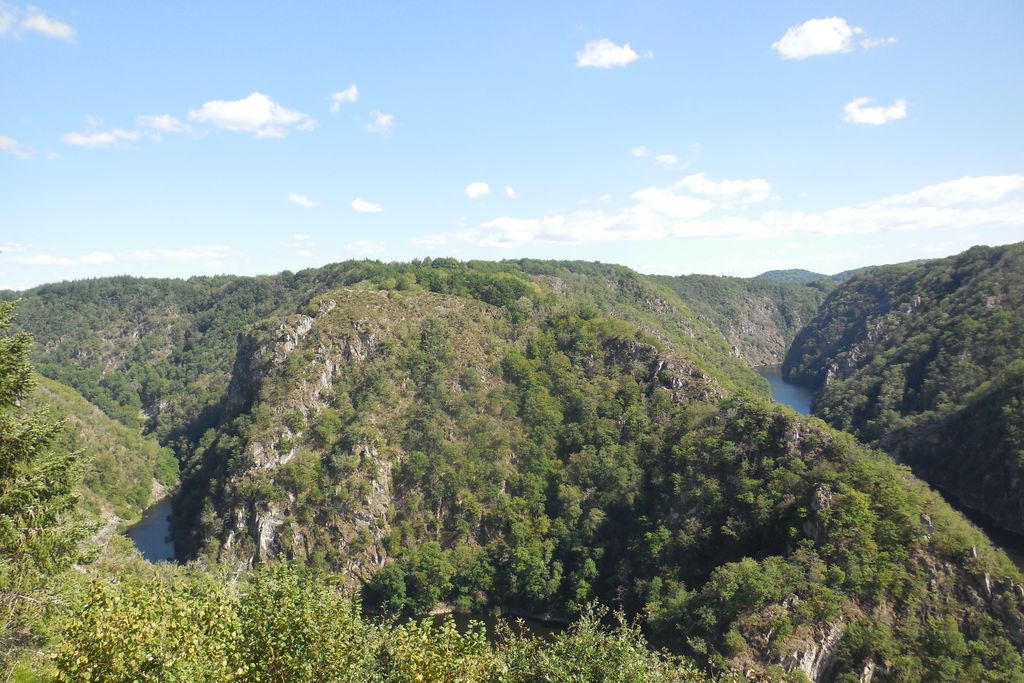
The atmosphere changes on the way back where small paths in the undergrowth overlook the Dordogne and lead to the viewpoints of Val Beneyte and the Grézolles (the confluence of Diège and the Dordogne).
The atmosphere changes on the way back where small paths in the undergrowth overlook the Dordogne and lead to the viewpoints of Val Beneyte and the Grézolles (the confluence of Diège and the Dordogne).
8 points of interest
G.Salat - CC HCC  Heritage site
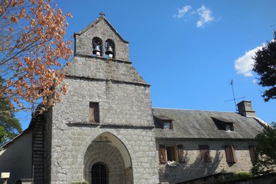
The village of Roche-le-Peyroux
Overlooking the town of Roche-le-Peyroux, the St-Pardoux church seems to protect the 96 residents, known as Rouchoux and Rouchounes, listed in 2017. On your return from the hike, don't hesitate to take a tour of the village, remarkable for its flowers and its stone;
Notice to the left of the church door the carved stone bearing the inscription SIGIG, whose meaning remains unknown.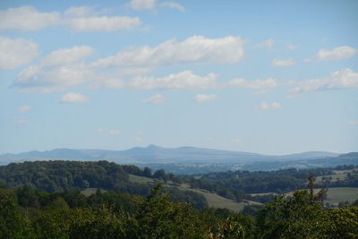
G.Salat - CC HCC  Panorama
Le Massif du Sancy
Behind the church, in the old cemetery, a picnic area offers a spectacular view of the Massif du Sancy. The highest volcano in mainland France at 1885 metres above sea level, this summit is the highest point in the Massif Central. The two streams, the Dore and the Dogne, originate there, and their confluence forms the Dordogne.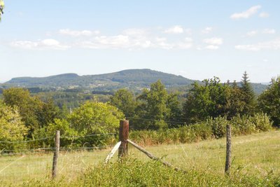
CC HCC PanoramaLe Puy de Bort
At the village of Bois du Peyroux, there is a magnificent viewpoint overlooking the Puy de Bort. At an altitude of 860 metres, this puy results from a volcanic flow coming from the Cantal. On its southern façade, which unfortunately is not visible from this point of view, the Dordogne has produced magnificent rocks like basalt organ pipes that dominate the town of Bort.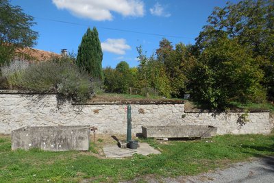
G.Salat - CC HCC PanoramaRotabourg and Les Chaumettes
The villages of Limousin were all strongly involved in agriculture. Walking through these hamlets always produces interesting discoveries during a hike: barns, mansions, crosses and monuments, traditional local architecture... As you enter Rotabourg, at the first barn, don't miss the small door in the embankment which corresponds to a cave. On the Place des Chaumettes, the old well has been replaced by a pump.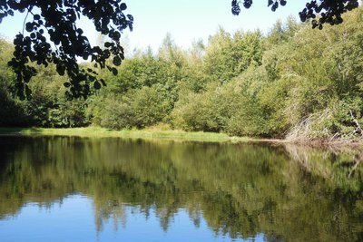
G.Salat - CC HCC  Pond
PondThe pond
While Haute-Corrèze is often identified as France's water tower because of the many rivers that have their sources there, it is also rich in a multitude of ponds and lakes. All artificial, they were created by humans, who most often dammed a stream at the end of a wetland, mainly for fishing.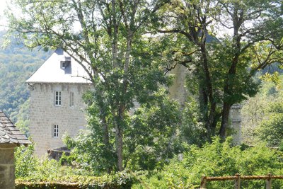
G.Salat - CC HCC Heritage siteThe château d’ Anglars
The Château d'Anglars is situated on a steep hill overlooking the Dordogne River, more than 250 metres above sea level. The château is behind an entrance gate (do not enter - private property that cannot be visited). Noted as early as the 13th century, under the jurisdiction of Ventadour, this fortress occupied a strategic place during the 15th and 16th centuries. You can see the main building and a square dungeon.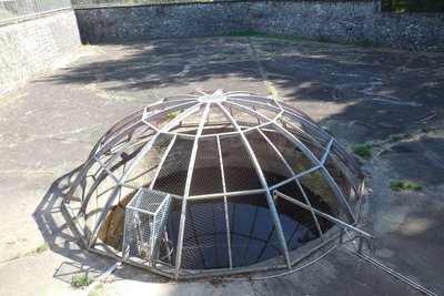
G.Salat - CC HCC Heritage siteThe Val Beneyte power station
Val Beneyte, the blessed valley, owes its name to a modest hermitage built on the banks of the Dordogne. The site, which was once a destination for excursions, was swallowed up in 1935 by the waters of the Marèges dam.
The village of Val Beneyte was built for the employees during the construction of the power plant. The power station is fed by a 2.6 km-long groundwater intake that starts at the Chaumettes dam and is extended by four penstocks that descend to the power station. The huge basin is an expansion basin that allows water to be stored in case of flooding. In the middle, the expansion chamber regulates the flow of water to the pipes.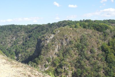
G.Salat - CC HCC PanoramaThe Grésolles Lookout point
This belvedere offers a magnificent view of the confluence of the Diège and Dordogne rivers and the site of St-Nazaire.
This place takes its name from the legend of the saint who supposedly drove the devil away.
A pilgrimage in his honour was organised by a Way of the Cross. During the ceremony, the inhabitants of Roche were grouped together on this belvedere, those of Cantal on the edge of the plateau. The three groups sang at the same time and the echoes reverberated through the valley.
Description
Park in the church car park. Go up alongside the cemetery, following the road to the Bois du Peyroux.
- Leave the l'Hors road on the left, go through the village of Bois de Peyroux; leave the Puy Sivadeau on your right.
- Follow the road to the right at the entrance to Rotabourg. Go through the village. 200 meters further on, at the crossroads, turn right then left to reach Les Chaumettes by a tarmac track.
- In this village, turn right, go past the well and then follow the Route des Bruyères on the left. At the crossroads go straight on. Continue straight on until you get to the D20, which you follow to the right for 100 metres.
- At the crossroads, follow the track on the left, which becomes a path through the undergrowth. At the pond, turn right, the path crosses a wood cutting area and joins a road. Follow it to the left, past the holiday camp.
- Before the gate of the château, on the left, follow a path along the ridge line high above the Dordogne. Turn right at the crossroads. Continue on the ridge to the village of Val Beynete.
- Turn left to go up to the village (out of the circuit: on the right, a short 50-metre round trip to the belvedere). After the last house, follow a grassy path on the right that continues along the ridge. Leave a path on the right to reach the Grézolles lookout.
- Continue on the road straight on to get back to the village. At the D20, turn left then right to find the starting point.
- Departure : Church, Roche le Peyroux
- Arrival : Church, Roche le Peyroux
- Towns crossed : Roche-le-Peyroux and Sainte-Marie-Lapanouze
Forecast
Altimetric profile
Recommandations
This circuit includes a section shared with the itinerary "From Villages to Dams" marked in yellow and white. Follow the markings carefully; the two routes separate after the village of Rotabourg
Information desks
Access and parking
From Neuvic or Liginiac, follow the D20 towards Roche-le-Peyroux and Bort-les-Orgues. The church is on the left as you leave the village of Roche-Le-Peyroux.
Parking :
Church, Roche le Peyroux
More information
Report a problem or an error
If you have found an error on this page or if you have noticed any problems during your hike, please report them to us here: